THIS HISTORICAL SOUVENIR
has been compiled to celebrate
THE OPENING OF THE BRIDGE
OVER THE NORTH SASKATCHEWAN RIVER
AT
LEA PARK, ALBERTA
CANADA
NINTH OCTOBER, 1957
BY THE
HON. GORDON E. TAYLOR
Minister of Highways
DIRECTORS IN CHARGE
OSCAR PETERSON, LEA PARK ....................................................... EXECUTIVE
JACK REINHEIMER, MARWAYNE .................................................. CHAlRMAN
TED CARSON, MARWAYNE ............................................................ SECRETARY
JOHN SPENCE ............................................................. MAYOR OF MARWAYNE
The Bridge Where Two Rivers Meet
1780 to 1957
GREETINGS
FROM E. C. MANNING
Premier of the Province of Alberta
The direct relationship between ease of transportation and the social and economic growth of an area always has been recognized by the Government of the Province of Alberta. The expansion of this province's highway facilities through a carefully planned and executed program has been of tremendous impact on this province's growth and economy in a comparatively few short years.
The opening of this $800,000 Lea Park Bridge marks an important advance in the provision of facilities for greater prosperity and convenience to residents of this district. I hope that this new structure will prove to be another step in the continued progressive development of this important area of our province. E. C. MANNING.
GREETINGS FROM J. M. DECHENE Member of Parliament for Athabasca
IT MIGHT PROVE of interest to those who will read this booklet, and I am sure there will be many, that I stated in a public meeting in 1913, at Frog Lake, I was convinced that I would live long enough to witness the construction of a fine bridge across the Saskatchewan River, at Lea Park. This has happened, and I am happy.
It occurs to me that I may better convey my thoughts and feelings in saying that I travelled the route which will now be served by this bridge a half century ago, over the old Battleford Trail south of the North Saskatchewan River to about the Fourth Meridian, where it crossed the river at an old Hudson's Bay fort called Fort Pitt; thence in a westerly direction through Frog Lake to St. Paul and the Saddle Lake Indian Reserve, and the north side of the Saskatchewan River through Pakan and on to' Edmonton, That old trail had been used far many years by the pioneer traders and settlers and was called the Victoria Trail. We used horses and democrat, which was the best vehicle to' travel these' trails at that time.
Lea Park appeared to us then to be the logical point far a bridge joining the country south of the Saskatchewan River to the Frog Lake and Cold Lake country. Our vision proved correct,
J. M. DECHENE.
GREETINGS FROM RAYMOND REIERSON Member of the Legislative Assembly for St. Paul
THE OPENING of the Lea Park Bridge climaxes fifty years of growth and development in the large community and bath sides of the North Saskatchewan river, which it will serve.
When backed by previous landmarks- of original settlement, schools, road building, railway, telephones, electrification and many others, it will no doubt be the key to' still greater progress, The mighty Saskatchewan has been a formidable barrier to freedom of movement. Even with goad ferry service it has dictated the seasons of isolation and uncertainty. It has contributed too of'ten to heavy hearts and fears far safety.
I hope that the use of this fine new structure will be rewarding beyond anything you may have expected.
RAYMOND REIERSON.
GREETINGS FROM J. A. SMITH Member of Parliament, Battle River-Camrose
OCTOBER 9th, 1957 will long remain in the minds of the people living to the north, south, east and west of the Lea Park Crossing of the North Saskatchewan River. It will be a day that has been anxiously awaited for many years. The early settlers of the area dreamed of the day when a bridge would span the river at this point. On the 9th this dream will come true. George Leslie will be able to discard his Page wire fence which was used for the annual cattle crossings; travellers will no longer have to worry about the ferry being closed down; the long "waits" at the ferry during rush periods will never again occur. These days will all belong to the past as the new Lea Park bridge will now serve, in a modern way, all those who wish to cross the river. Those individuals who have for years urged the construction of this bridge will undoubtedly feel that their efforts down through the years have been fruit-fully rewarded.
J. A. SMITH
GREETINGS FROM. ANDERS O. AALBORG Member of the Legislative Assembly for Alexandra
Gone are the days of partial isolation for those who live north of the river. For everyone, both north and south a new era of easier and more convenient transportation and communication has begun.
ANDERS O. AALBORG
Scow for Sale!"
by
GORDON E. TAYLOR, Minister of Highways
WHEN Alfred Lord Tennyson wrote "Ring out the old, ring in the new" I am sure that he was not thinking of ferries and bridges. His words nevertheless appear most applicable on the occasion of the closing of the Lea Park ferry and the opening of the bridge.
"Ring out the old!" - For nearly fifty years the people of the area have been taking their children, their cattle and commerce across the North Saskatchewan River by means of a scow. At times the service was wonderful and was praised; on occasions the service was terrible and was cursed. There was always the concern should an emergency occur in the spring and fall when the ferry could not operate. A scow subject to so many varying factors cannot give complete satisfaction.
Through it all though I think we can say that the ferry has performed a good job even though few tears will be shed as the ferry makes its last ride. The final trip will ring out the historical period of the Lea Park ferry.
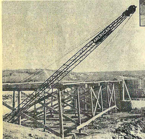
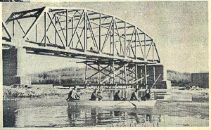
"Ring in the new!" - The new steel through truss type bridge built on a concrete sub-structure will replace the uncertainties, the inconveniences and the delays of the scow with an easy flow of commerce and travel and an absence of worries and fears. In spring and summer, winter and fall it will be there waiting and ready to serve. It rings in a new historical period promising easier travel, increased prosperity and bountiful happiness.
"Ring out the old! Ring in the new!"
Interesting Facts About the Lea Park Bridge
by
GORDON E. TAYLOR, Minister of Highways
3400 CUBIC YARDS OF CONCRETE.
176,000 POUNDS OF REINFORCING STEEL.
850 TONS OF STRUCTURAL STEEL.
COST OF THE BRIDGE NEARLY $800,000.
The bridge was designed by the Engineers of the Bridge Branch of the Department of Highways. The Chief Bridge Engineer is L. H. McManus; the Assistant Chief Bridge Engineer is Victor McCune; Chief Design Engineer is Mr. Thomas Trimble.
Canoes beached at this spot on north bank of N. Saskatchewan River to land traders for
nearby Hudson's Bay and Northwest Company forts.
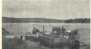
Scows brought early settlers and their few worldly goods to build a new land.
Progress was marked by a cable ferry moved to and fro across the river by the current.
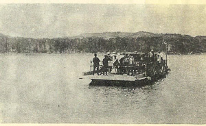
And finally, a motor powered ferry unites communities on both sides of the river.
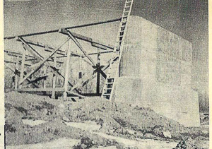
Another step in the conquest of the river takes shape as steel joins shore and pier over preliminary false-work.
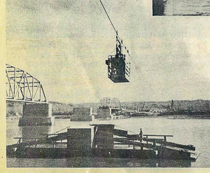
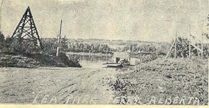
Alert photographer has captured three forms of man's victory over the river,---bridge, ferry and cable car.
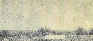
A lonely pile of lumber dots the rolling countryside at the spot where a new town is soon to be born---- Marwayne ·1926
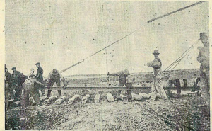
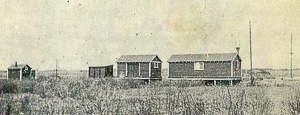
Steel is laid to bring the railway in 1927, followed by the station house and accompanying outbuildings.
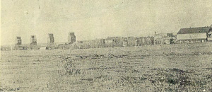
Marwayne has a skyline. Elevators. business buildings and homes line the horizon where only two years before Alberta pains rolled endlessly.
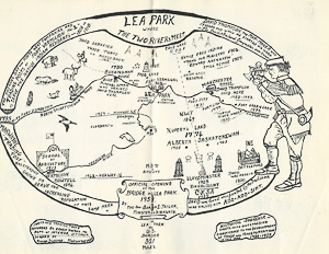
QUOTES [rom. the records of E. VOORHIS, to the Department of the Interior, Ottawa, 1930, concerning posts shown on the Map on the centre page:
BUCKINGHAM HOUSE - Hudson's Bay post on North Saskatchewan River, near the North-West 00. post of Fort George built in 1780 by Mitchell Oman. Abandoned in 1801 in favour of Island Fort, 18 miles further up the river in Sec. 19, Twp. 56, Rge. 5, W4th Mer. David Thompson visited this part 1793-94.
FROG LAKE HOUSE - Small H. B. C. post on Frog Lake, about 30 miles from Fort Pitt, north of the river. In the rebellion 'Of 1885this post was raided by Indians and destroyed by fire, the garrison occupants being massacred.
FORT VERMILION No.2 (now Lea Park) - Both the N. W. Co. and the H. B. Co. built closely adjoining forts called Vermilion in 1808 on north side of N. Sask. river directly opposite the mouth of the Vermilion River, Alberta. Both these forts were abandoned on the same day, 31 May 1810, and their goods were transported to new forts at the mouth of White Earth river, about 87 miles upstream. The H. B. Co. maintained their post at White Earth river until
about 1870.
FORT PITT - H. B. Co. post, was a square palisaded and bastioned fort situated about 100 yards from the river. Built in 1831 it was a small establishment in 1862 principally used as a provision post for dried meat. Treaty signed with the Indians in 1875. Raided in the rebellion of 1885, not restored after.
MANCHESTER HOUSE - H. B. Co. post on the north bank of North Sask. river, built by David Thompson in 1786, and resided there till it was abandoned in the autumn of 1793. Closed about 1860.
TURTLE RIVER HOUSE - North-West Co. post on south side of river near what is now the town of Delmas, Tp. 46, Rge. 18, W3rd Mer. In 1800 David Thompson found this post in ruins.
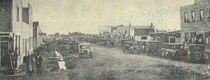
Marwayne's main street is lined with visitors to a Sports Day held in July. 1927.
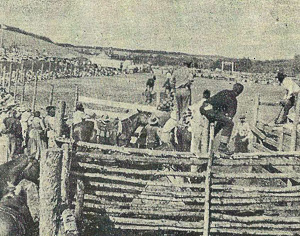
Thirty years later people gather to the excitement at Lea Park Stampede.
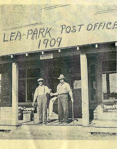
Landmark for nearly half a century is the Lea Park Post Office. Two fishermen of the district hold a "big one" that didn't get away.
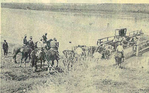
Fine beef cattle on their way to market are herded onto the ferry.
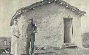
Skill and industry of the pioneer settler moulds materials at hand into a home.
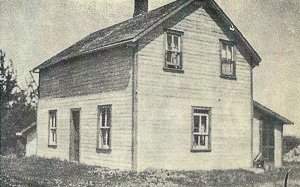
Time passes and a more modern dwelling takes place of the log or sod âshanty."
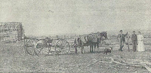
Mail driver from Islay to Marwayne stops to visit with settlers on his route in 1905.
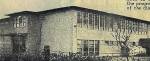
New school opened in 1955 is a symbol of the progressive spirit of the district.
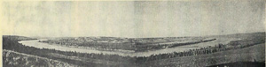
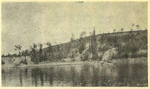
From high on a hill this panoramic picture shows the meander ings of theNorth Saskatchewan River near Lea Park. Location of the new bridge (left) is indicated by a line across
the river near the centre of the right half of the picture.
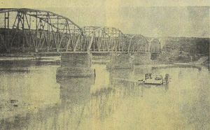
Ferry and Bridge
The Bridge Where Two Rivers Meet
By ROSINA DUDLYKE
The location of the bridge spanning the North Saskatchewan River at Lea Park, Alberta, Canada, is a short distance west of Fort Vermilion No 2, where in 1808 to 1810 The Hudson's Bay and North-West Companies had adjoining trading posts, almost in the centre of many historical landmarks dating from 1780 as recorded by Ernest Voorhis, A.M., Ph.D., Department of the Interior, Ottawa (1930). Buckingham House to the west of this bridge was built by Mitchel Oman who trained David Thompson to trade and barter with the native Indians.
This Welsh youth was orphaned when he was two- years of age, later being placed in the charity "Grey Coat" School in London, England. For seven years he studied hard until at 14 years he was apprenticed to The Hudson's Bay Company for the next seven years and was sent to Rupert's Land, Canada, in 1784 as "a boy trained in both mathematics and navigation". By the time he was 17 he came to Buckingham House and two years later was sent to manage affairs and build up Manchester House (not far from where Fort Pitt later became a H.B.C. post in 1831) where he lived until 1793. From this place David travelled far and wide to accomplish the wonderful work that in this year, 1957, was recognized by the Dominion of Canada by the issue of a five cent stamp in commemoration of the world's greatest inland geographer ever known, embodying the results of his surveys and explorations from 1789 to 1812 in the "First accurately prepared Map" of Canada's Great West. Beloved and respected by the Indians of many tribes who gave him the name of Kco-Koo-Sisit in tribute to "the man who looks at the stars" (1790).
Kerry Wood of Red Deer in his book "The Map Maker," gives a splendid account of David Thompson's life and work following his searchings and reports in our part of Canada.
At Lea Park on the north side of the river the cellars of Fort Vermilion No.1 still exist in a good state of preservation. On the picture showing the river at this point the ramp can clearly be seen where the traders hauled the goods up from the canoes which were the means of travel in 1808. It is hoped that this historic site will soon be officially marked.
Also close to this vicinity was where W. B. Cameron, the author of "War Trails of Big Bear", now known as "Blood Red the Sun" escaped the massacre at Frog Lake in 1885. On the south side of the river on the sand bar by the mouth of the Vermilion River is where the scows landed the early pioneers in 1904 after travelling from Edmonton on the river. Further down the river at Hewitt's Landing was where loads of lumber on rafts were unloaded in July, 1903. At nearby Fort Pitt other pioneer settlers landed in 1904.
Lea Park was named by Mrs. Martha Graham of Riverton. The first ferry was installed in 1908, operated by one man until 1930, then by two men until 1947, when three' men were appointed and continuous service provided. The first power unit was installed in 1944. The total vehicular traffic in 1926 was 5,580, but by 1956 this had climbed to 22,287.
Lea Park had its first post office in 1909, which was continuously operated until 1955 when it was discontinued.
Highway 4!5 is but six miles south of Lea Park where it turns south to Marwayne, which trading centre had its first post office in 1905. But with the coming of the Canadian Pacific Railway in 1926, from a pile of lumber on open land has grown this progressive business centre to serve the increasing population, A water and sewer system was completed in 1957.
All this development since 1780 is but the promise of greater things to come and the possibility of a main highway from Lea Park to the United States border, a distance of 321 air miles.
ON THE FOUNDATIONS OF THE PAST
WE BUILD IN THE PRESENT
FOR THE BETTERMENT OF THE FUTURE.
* * * * * *
PHOTOGRAPHS
by courtesy of
Mrs. Wm. Ashworth Sr., Marwayne
Mrs. W. S. Campbell, First Storekeeper at Marwayne
Mrs. R. Dudlyke
Mr. Vaughan Smith
Mr. Dick Hines
CENTRE PAGE
A Tribute to DAVID THOMPSON, AND THE DEVELOPMENT OF THIS AREA
RESEARCH and DESIGN
BY MRS. ROSINA DUDLYKE, Marwayne, Alberta.
ENGRAVING by:
DON H. FLACH, 11223 - 77 Avenue,
Edmonton, Alberta.
PRINTED and PUBLISHED by:
VERMILION STANDARD LTD.
Vermilion, Alberta.